Deep learning based on uav data for super resolution of multispectral satellites scenes
Keywords:
deep learningAbstract
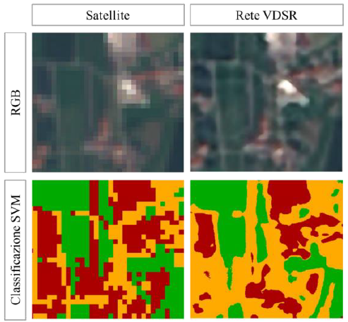
Nowadays different remote sensing technologies allow to acquire images over extended areas; the choice of the most suitable platform must be evaluated according to the scale of application, purpose of the study and cost analysis. In this frame, especially when the use of a specific platform does not prevail, it may be interesting to combine the use of different technologies to benefit from the strengths of each one. The main topic of this study is to evaluate the potentiality of deep learning technology, in particular the VDSR neural network, to obtain an improved resolution product starting from free low resolution satellite images (10 m), based on the information learned from high resolution data (cm) acquired by drone. The improved quality image is intended to be used for vegetation monitoring: in this context the use of multispectral data is important, helping in the calculations of indices or elaborations of classifications. To achieve this goal, tests are carried out on areas of different extension concerning an agricultural area near Boves (CN), using images acquired by drone, characterized by different types of vegetation, for training the neural network. The obtained results encourage further studies on this topic, although the actual application on real cases might be affected by other factors, like the required computing power and time factor compared to other methods of spatial resolution improvement of images.
Downloads
Downloads
Published
How to Cite
Issue
Section
License
Copyright (c) 2021 Marina Casabona, Nives Grasso, Andrea Maria Lingua (Author)

This work is licensed under a Creative Commons Attribution-ShareAlike 4.0 International License.

