Evaluation of effect of prescribed fires using spectral indices and SAR data
Keywords:
SAR, Sentinel-1, forest fireAbstract
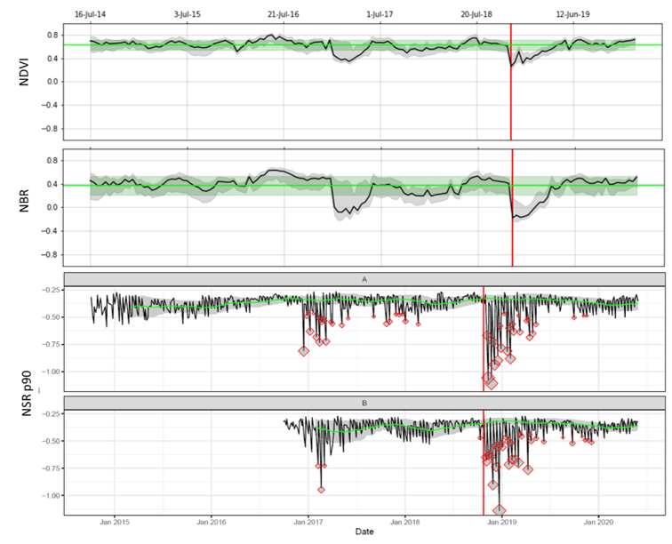
In this work, satellite data from passive (~ 300 Landsat images) and active radar / SAR (~ 650 Sentinel-1 images) sensors were used to assess the capability of semi-automatic identification of areas crossed by two different types of fire. The results compare indices calculated from passive optical satellite imagery, known in literature to be related to vegetation status and fire severity (NDVI and dNBR), and a method that uses only active radar data.
The fires analyzed are divided into three groups, prescribed fires (artificial and controlled), autumn-winter fires and summer fires (natural, uncontrolled). An hypothesis to test was that natural summer fires to have a greater impact than others as the season predisposes to greater severity. Two aspects were analyzed: the recovery time, i.e. how long the area takes to return to the previous values of NDVI and NBR, and the severity, that is the difference in vegetation status before and after the fire.
The optical data results clearly show that there appears to be no difference in the time it takes for an area covered by a fire to return to pre-fire values, although there is a faint sign that summer fires appear to take on average more recovery time. With NBR it appears that prescribed fires and autumn-winter fires take an average of ~ 200 days, while uncontrolled summer fires take 308 days. A significant difference was identified regarding the severity of the summer fires compared to those prescribed, while no differences in severity were found between prescribed vs autumn-winter and autumn-winter vs summer. The SAR data were analyzed using threshold values with the Smoothed Z-score method on a moving window, it appears to have an ability to identify areas affected by fire on 19 of 39 areas (48%) using the 90th percentile of normalized values of VV and VH on the area. This percentage increases to 95% if the NBR data is used as a reference instead of using only the dates of the fires reported by the relevant agencies.
Downloads

Downloads
Published
How to Cite
Issue
Section
License
Copyright (c) 2022 Joyce Machado Nunes Romeiro, Fillipe Tamiozzo Pereira Torres, Francesco Pirotti (Author)

This work is licensed under a Creative Commons Attribution-ShareAlike 4.0 International License.


